If you love to go trekking, then you surely won’t be disappointed if you decide to visit Brazil. In all 5 regions of the country, you have a ton of opportunities to venture into beautiful trails and be rewarded with beautiful landscapes that range from paradisiac beaches to lush green forests.
The best places to go trekking in Brazil are
In this post, we are counting down the best 10 places to go trekking in Brazil. We will go over the best time of the year to visit each of them, go over their length, difficulty levels, the basic items which you should bring in all of them, and give you all the necessary information for you to start making your travel plans.
1. Rio do Boi Trail – Parque Nacional Aparados da Serra (RS)
Course Lenght: 5 miles
Difficulty Level: high
Average Time to Complete: 5 to 8 hours (considering pit stops)
Guide Needed? some trails require a guide
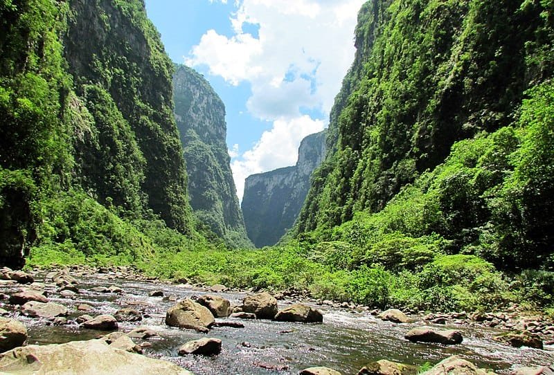
This trail is located in Canyon Itaimbezinho, housed by the Aparados da Serra National Park in Rio Grande do Sul, south of Brazil. During the trekking, you can see the transition between the Atlantic and Nebular Forests in their various stages of growth.
The Rio do Boi trekking tour is much appreciated and considered exciting by both natives and visitors looking to be more in touch with nature. In addition to the Rio do Boi trail, you can also venture at the Vértice and Cotovelo trails as well.
This is arguably one of the most beautiful trails in the Aparados da Serra National Park, mainly due to its unmistakable and peculiar landscape. It is an impressive trail filled with many fauna and flora species and its fascinating shapes and colors are very inviting for some pretty great pictures!
How To Get To Parque Nacional Aparados da Serra
The best way to get to Parque Nacional Aparados da Serra is by landing at Porto Alegre’s International Airport (Aeroporto Internacional Salgado Filho – POA), and renting a car to drive to the Park. You will head towards Praia Grande (SC), and will drive about 135 miles a road in excellent condition.
If you want to learn more about car rentals and how do they work in Brazil, take a look at this post we made, where you will also be able to read the main points of interest in regards to Brazilian traffic laws.
Best Time To Go To Parque Nacional Aparados da Serra
You can go any time of year. However, there are two important climatic characteristics: between November and February, the overall temperatures are warmer and the visits to the local waterfalls and crossing rivers are more pleasant, as the South of Brazil is known for being the coldest region in the country.
However, it is also more likely to rain during the Summer season, which makes rivers fuller, and sometimes clouds can blcok the view of the canyons. During the winter, (between June and August) the weather isn’t as humid and the probability of rain is much lower, as well as the average temperature.
What To Bring To Parque Nacional Aparados da Serra
- a good pair of hiking shoes (preferably waterproof)
- slippers or crocs
- an extra pair of socks (in case you get your feet wet, even with the waterproof shoes it could still happen)
- 1 windbreaker coat
- 1 thermal suit to wear underneath your clothes (if it’s cold)
- 1 pair of confortable pants that allow you to move freely
- hat, a pair of gloves, a cap, a mask to protect your mouth and nose area
- a light change of clothing
- underwear
2. Lençóis Maranhenses Trail – Maranhão (MA)
Course Lenght: 3 days
Difficulty Level: medium
Average Time to Complete: 4-5 hours (each day)
Guide Needed? no
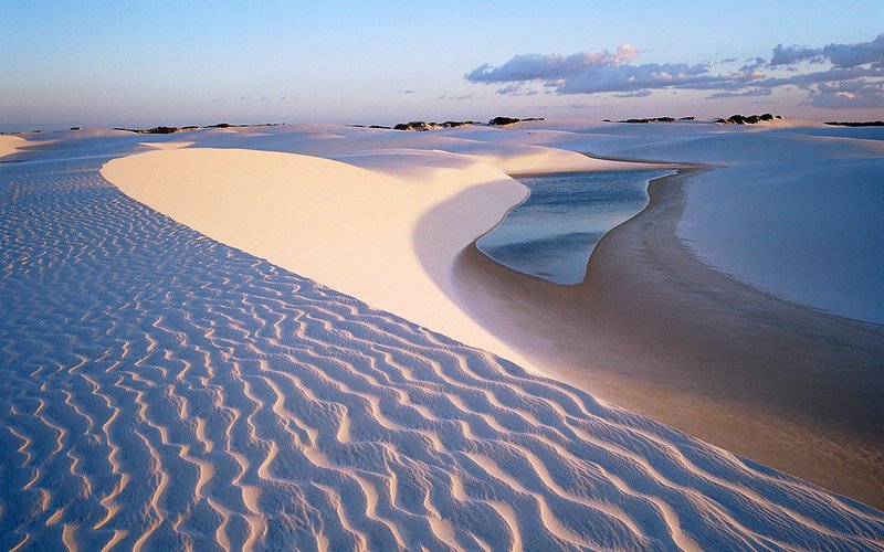
Trekking at the Lençóis Maranhenses is considered one of the most fantastic trekkings in all of Latin America. The tour consists of a mixture of untouched desert landscapes of dunes and oasis with crystalline natural lagoons that make this expedition pretty unique in all of Brazil.
The Lençóis Maranhenses Crossing is located in the Lençóis Maranhenses National Park, on the coast of Maranhão, Northeast of Brazil. You will be able to take lots of pictures in an unique landscape with white sand dunes and beautiful locations like Lagoa Azul and Lagoa Bonita, which are the most visited places in the region.
How To Get To Lençóis Maranhenses
The best way to get to the Lençóis Maranhenses is by landing São Luís International Airport (Marechal Cunha Machado – SLZ). From the airport, you can rent a car and drive to Barreirinhas, Santo Amaro or Atins, which is where the Lençóis Maranhenses trekking tour departures.
Just keep in mind that you will not be able to enter the reservation area where the Lençóis Maranhenses are located by car, as the area is restricted for vehicles accredited by ICMBio.
Best Time To Go To Lençóis Maranhenses
The rainy season in Lençóis Maranhenses extend from January to June and has its peak in the months of February to May. It is during this period that the lagoons fill up and the landscape becomes a paradise for tourists. For those who want to travel at the height of the flood, the ideal is to go to Lençóis Maranhenses in April and May.
The downside of these two months, however, is the possibility of still getting many rainy days in the region. To make sure you will get beautiful sunny days and full lakes, the best time to go to Lençóis Maranhenses is between the months of June, July, and August.
It’s also very important to check the weather forecast when you are making your plans, as the rainy season can vary a lot from year to year.
What To Bring To Lençóis Maranhenses
To the City
- t-shirts
- shorts and shorts dresses
- long-sleeved blouses made from light fabrics
- light fabric pants (to wear at night when it cools down and the mosquitoes appear)
- slippers / flip flops
- panties / underwear
- bras or tops
To the Dunes
- bikini / swimwear shorts
- light t-shirts
- blouse with UV protection
- sunglasses
- hat with strps (so they don’t fly with the wind)
- turban (if you have very little hair and suffer from peeling scalp
- trekking slippers or sandals
- water and snacks
- a towel
3. Vale do Pati Trail – Chapada Diamantina (BA)
Course Lenght: 3-4 days
Difficulty Level: medium-high
Average Time to Complete: 5-6 hours (each day)
Guide Needed? yes

Vale do Pati is a huge valley (with a relatively difficult access) housed by the Chapada Diamantina National Park, an area protected by the Chico Mendes Institute (ICMBio). For a long time, the region was used to extract diamonds, and then to plant coffee.
There are immense hills, different rock formations, lush green fields and stunning rivers and waterfalls. It is possible to make the route from Mucugê, Capão or Andaraí, on a trek that last from 1 to 4 days, with no telephone signal and no internet access.
But I highly doubt that you will miss them after passing through unforgettable spots such as Morro do Castelo , the Pati Observatory and the Funis Waterfall.
How To Get To Chapada Diamantina
The best way to get to Chapada Diamantina is by landing at Salvador’s International Airport (Dep. Luís Eduardo Magalhães – SSA), where you will need to take another flight to the Lençóis Airport (LLC). Flights from Salvador to Lençóis are not available every day of the week and only depart on Thursdays and Sundays as standard.
By the way, if you want to make a pit stop in Salvador, here’s a video to give you a quick guide on what you’ll be able to see over there:
So if you want to go trekking at Chapada Diamantina, I would highly suggest you to plan yourself very carefuly, especially if you plan on hiring a tour prior to arriving in Brazil.
Best Time To Go To Chapada Diamantina
For the trekking fans, the best time to go to Chapada Diamantina is in from May to October, as the temperature will be perfect for outdoor activities and there is almost no risk of rain, which makes walking the trails much easier.
As the weather won’t bu as humid as in the other periods, the trails also won’t be as slippery and it even makes the landscape much more beautiful as well.
What To Bring To Chapada Diamantina
- windbreaker coat
- rain coat
- sunscreen
- bug spray
- a hat
- bikini / swimshorts
- a plastic bag for dirty/wet clothes
- a pair of long pants
- a pair of thick socks
- sandal or flip flops
- a small backpack with wide straps
- shorts / bermudas
- t-shirts
- a pairs of confortable sneakers (waterproof if possible)
- a towel
- a canteen
- long sleeve t-shirts
4. Provetá x Aventureiro Trail – Ilha Grande (RJ)
Course Lenght: 1 day
Difficulty Level: high
Average Time to Complete: 1 and a half hours
Guide Needed? no guide necessary
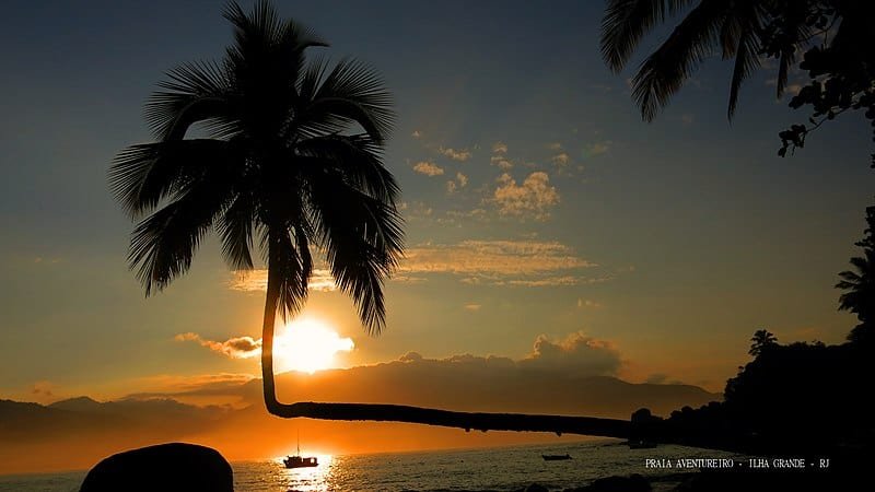
The Provetá x Aventureiro trail has a little over 2 miles and crosses through the highest altitude of all the trails around the island. After a long climb, you will be able to spot a few improvised benches in case you need a rest and there is even a rare spot that picks up cell phone signal on that side of the island. Then down down you go!
Overall, the trail requires a little bit of physical preparation, as you will be facing some steep climbs. The reward if getting to the Aventureiro Beach, one of the most beautiful spots in Ilha Grande. If you are planning on staying the night here, be aware that there are no inns, hostels, or even cell phone signal, but there is a campning site with wi-fi!
How To Get To Ilha Grande
The best way to get to Ilha Grande is by landing at Rio de Janeiro’s International Airport (Aeroporto Internacional Tom Jobim – GIG) and then taking a bus to a city called Conceição de Jacareí. Since Ilha Grande is an island, it can only be reached by boat, and the nearest and most convinient place to board in on Conceição de Jacareí.
There are no cars allowed in Ilha Grande, so make sure to pakc you bags considering that you will have to carry them once you get to Conceição de Jacareí.
Best Time To Go To Ilha Grande
The best time to go to Ilha Grande – and by that I mean the period when there is less chances of raining – is from May to August. During this somewhat short period of time (between late autumn and early winter), the overall weather is pretty good, so you will most likely be spending some sunny days in Ilha Grande.
In addition, the months of April, September, October and November are also historically known for less occurences of rain, but be aware that heavy clouds may be part of your trekkings around Ilha Grande..
What To Bring To Ilha Grande
- a confortable pair of sneakers
- comfortable light clothing for trekking – some people wear jeans and only the top of the bikini, but leggings or sports shorts are much more comfortable for a long trail
- a flashlight
- a towel
- windbreaker jacket
- an extra pair of socks
- an extra change of clothes
- flip flops or sandals
- snacks
- garbage plastic bag for litter
5. Monte Roraima Trail – Roraima (RR)
Course Lenght: 6 days
Difficulty Level: high
Average Time to Complete: 4-5 hours
Guide Needed? guide is mandatory
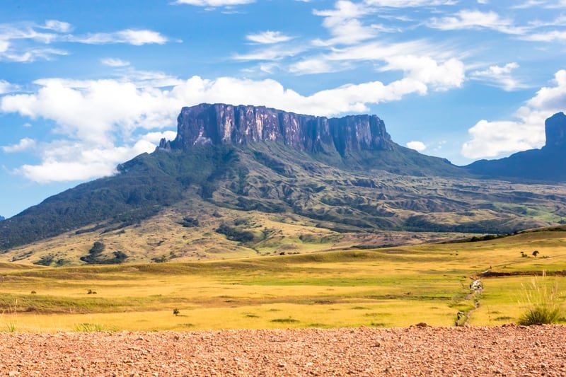
Mount Roraima is the seventh-highest point in Brazil, at 2,875 meters of altitude, on the triple border between Brazil, Guyana, and Venezuela. If the height wasn’t enough, the place is impressive for its shapes carved into the rocks and walls caused by the action of the winds amidst the Amazon savannas.
Challenges and obstacles are, of course, expected: there are many rivers, rock formations, and winds of up to 62 miles per hour, in addition to a temperature variation between 5 and 35 degrees (Celcius). Safe to say that if you like trekking, you will have plenty of fun at Monte Roraima.
Oh, and if you have watched the Pixar movie Up!, the Paradise Falls location was inspired by Mount Roraima! Pretty cool, huh?
How To Get To Monte Roraima
First of all, you will need to hire a guide for your expedition to Mount Roraima, as this is no ordinary trail! There are many specialized companies that are qualified to take you safely to the top of the mountain and believe me, you will need some help.
After you have decided on your guide, you will need to get to Venezuela, which is where the entrance to Mount Roraima is located. After landing in
By taxi or Uber, you should go to Terminal do Caimbé in Boa Vista. You can play Caimbé in the app and explain to the driver that you want to stop at the Terminal. From Caimbé, take a taxi to Pacaraima (Brazil x Venezuela border). These taxis stay there until full (capacity type) and charge $50 per person. Arriving in Pacaraima, you should already find your guide who will take you to Santa Elena de Uairén, Venezuela, to spend the night.
Best Time To Go To Monte Roraima
Most travelers prefer to climb Monte Roraima between the months of September and March, but there are others that recommend going in May as well. The weather up there is pretty unstable and there is no way to predict whether it will be sunny or rainy regardless of the season.
What will make the difference is the route that will lead you to the top, so if you happen to go on a hot sunny day, that might affect your trekking because of the heat. Not to mention that the places you can choose to go camping are less crowded during the unpopular seasons, which means you can have the best spaces to accommodate yourself.
What To Bring To Monte Roraima
So, to back your backpack to climb Mount Roraima, you first must consider the amount of time you are planning to stay there. There is more than one type of tour on Mount Roraima, the most common being a 7-day trekking tour, consisting of 4 days of walking for both legs and 3 days of accommodating up there.
The most common itineraries cover the following locations: the Tripple Frontier, Valley of the crystals, Maverick Stone, Jacuzzi, El Foso, Abismo and Mirante do índio.
Here are the main items you will need in Monte Roraima:
- a good pair of hiking shoes (preferably waterproof)
- slippers or crocs
- 1 or 2 pieces of cotton clothing and a thick pair of socks for sleeping
- 5 pairs of socks (even with waterproof boots/sneakers, your socks will most likely get wet and wearing them wet can cause wounds, so it is better to take a few extra pair so you can change),
- 1 windbreaker coat
- 1 thermal suit to wear underneath your clothes
- 2 pair of confortable pants that allow you to move freely
- hat, a pair of gloves, a cap, a mask to protect your mouth and nose area
- 3 changes of clothing
- underwear.
Other than that, it is also highly advisable for you to consider taking the following items:
- canteen
- water disinfectant
- bug spray
- the anti-allergic that you are used to taking (even with repellent some mosquitoes might still bite)
- vitamin C
- a sleeping bag
- camping tent (if you can’t take one, you can rent it with the guide)
- a thermal sleeping bag (for the ones who feel the most cold)
- head lamp
- trail pole for trekking, very important item
6. Portais de Hércules Trail – Serra dos Órgãos (RJ)
Course Lenght: 1 day
Difficulty Level: medium/high
Average Time to Complete: 7-9 hours
Guide Needed? yes
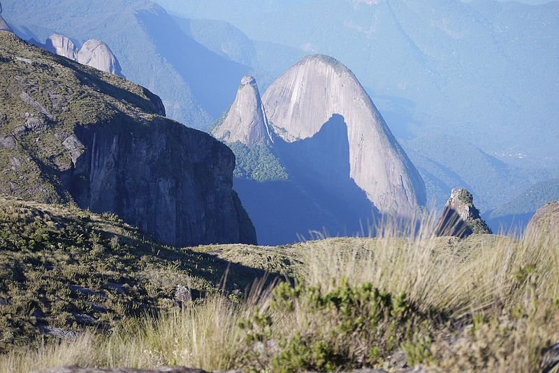
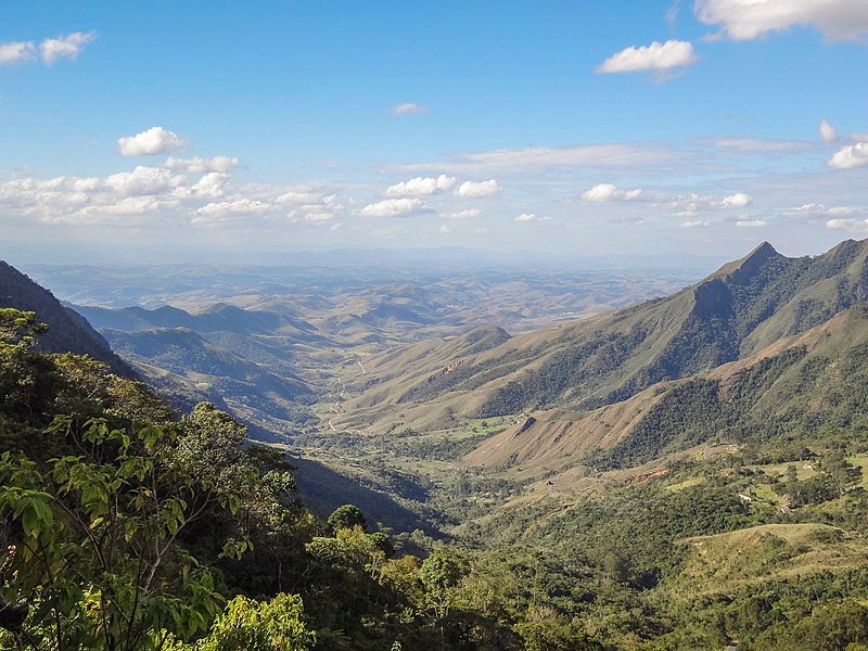
With a very privileged view of the entire Serra dos Órgãos mountain range, the viewpoint known as Portais de Hércules (located between Petrópolis and Teresópolis) is another trail in Brazil that allows for contemplating breathtaking landscapes.
For the more experienced and those with good physical conditioning, it is possible to do the trail to the Portais de Hércules in one day, but be aware as the trail from Açu to the Portals of Hercules is not very well signposted like the other trails within the Park, so it’s best to hire a guide.
While facing directly across the viewpoint, you will be able to see a face carved in the rock formation that resembles the Greek God Hercules, which is the reason why the place is known as Hercules Portals.
How To Get To Serra dos Orgãos National Park
The best way to get to Serra dos Orgãos is by landing at Rio de Janeiro’s International Airport (Aeroporto Internacional Tom Jobim – GIG) and then taking a bus or renting a car to get to Teresópolis (which we have previously mentioned in this article). It takes a little over an hour and a half to get there and the ride is pretty smooth.
The main entrance to the Serra dos Órgãos National Park is located in the urban area of Teresópolis, on Avenida Rotariana. The park entrance is right next to the bridge over the Paquequer River, at the entrance to the city. It is also very close to the Soberbo Observatory and the city’s portal.
Best Time To Go To Serra dos Orgãos National Park
The best time of year to go to Serra dos Orgãos and make the Portais de Hércules crossing is during the winter (from June to September), as in most mountain places: Summer is the coldest period to go trekking due to the constant rains. During the winter, you will get to experience warm days, although the temperature after night falls is absolutely freezing.
What To Bring To Serra dos Orgãos National Park
- a confortable pair of sneakers
- comfortable light clothing for trekking – some people wear jeans and only the top of the bikini, but leggings or sports shorts are much more comfortable for a long trail
- a flashlight
- a towel
- windbreaker jacket
- an extra pair of socks
- an extra change of clothes
- flip flops or sandals
- snacks
- garbage plastic bag for litter
7. Trilha do Ouro Trail – Paque Nacional da Serra da Bocaina (SP)
Course Lenght: 3 days
Difficulty Level: easy/.medium
Average Time to Complete: 4-5 hours
Guide Needed? no guide necessary, but it is recommended to hire one
Trilha Dourada (which means Golden Trail) is one of the most interesting tours of the Serra da Bocaina National Park, located at the border between the states of Rio de Janeiro and São Paulo. The trail is an old colonial path from the 17th century built by the native indigenous tribes to transport the gold that came from Minas Gerais. So expect beautiful landscapes for you pictures!
The trail, which runs across the Serra da Bocaina from one end to anotherin a route of a little over 30 miles, has a degree of difficulty from moderate to high. Although there are no stretches of technical difficulty, it can be an extenuating hike that lasts 3 days and passes through a region of uneven terrain.
But rest assured, all your physical efforts will be greatly rewarded with beautiful and historical places, such as the centenary farms, the ruins of an old sugarcane mill, and the most beautiful waterfalls in the region, such as Santo Izidro, Veados and the Cachoeira das Posses.
How To Get To Serra da Bocaina National Park
The best way to get to Parque Nacional da Serra da Bocaina is by landing at the São Paulo International Airport (Congolhas – CGH) and taking a tour bus or renting a car to make the rest of the trip by land. From the airport to the Park’s entrance, you should take around 3 and half hours to get there.
Best Time To Go To Serra da Bocaina National Park
In theory, the best time to visit the Serra da Bocaina National Park is between the months of May and August, which is when it is less likely to rain. However, this is also the coldest period in the region, and, therefore, less favorable for waterfall baths.
So considering the temperature, going to the Serra da Bocaina National Park during the Summer (December to March) could mean that the rain will make the trail more difficult, but at least you will be able to take a dip at the waterfall’s well.
What To Bring To Serra da Bocaína National Park
If you are planning on taking the full 3-day trekking tour at the Serra da Bocaína National Park, then you must be prepared for various situations. Here are some of the main items you will need during your stay at the park:
- a good pair of hiking shoes (preferably waterproof)
- slippers or crocs
- 1 or 2 pieces of cotton clothing and a thick pair of socks for sleeping
- 5 pairs of socks (even with waterproof boots/sneakers, your socks will most likely get wet and wearing them wet can cause wounds, so it is better to take a few extra pair so you can change),
- 1 windbreaker coat
- 1 thermal suit to wear underneath your clothes
- 2 pair of confortable pants that allow you to move freely
- hat, a pair of gloves, a cap, a mask to protect your mouth and nose area
- 3 changes of clothing
- underwear
Other than that, it is also highly advisable for you to consider taking the following items:
- canteen
- water disinfectant
- bug spray
- the anti-allergic that you are used to taking (even with repellent some mosquitoes might still bite)
- vitamin C
- a sleeping bag
- camping tent (if you can’t take one, you can rent it with the guide)
- a thermal sleeping bag (for the ones who feel the most cold)
- head lamp
- trail pole for trekking, very important item
8. Ponta da Joatinga Crossing – Paraty (RJ)
Course Lenght: 4-7 days
Difficulty Level: high
Average Time to Complete: around 7 hours (each day)
Guide Needed? no guide necessary, but it is recommended to hire one

Ponta da Joatinga is a cape located in Paraty, south of Rio de Janeiro. The trail consists of an extremely beautiful route that passes through mountains, deserted beaches, waterfalls and a vast green area protected by the Atlantic Forest.
Like our last suggestion, this crossing can take up to three days to be completed, as you will traveliver over 12 miles of trekking from moderate to difficult, depending on your level of experience. Safe to say that the landscapes you will find on the way are so beautiful that you may not even notice you are tired!
You will discover attractions such as Martim de Sá and Ponta Negra beaches, the Saco Bravo waterfall and many other exuberant attractions. And if you want to know more about why you should include Paraty on your itinerary next time to you come to Brazil, take a look at this post we made and we’ll give you XX good reasons on why you are missing out!
How To Get To Paraty
The best way to get to Paraty is by traveling to the city’s closest airport, which is the Galeão Airport (Antônio Carlos Jobim Airport – GIG), located in Rio de Janeiro. From there, you can go by car, on a journey that takes approximately 4 hours, by bus, or by Uber.
Best Time To Go To Paraty
The best time to go to Paraty is during the dry season, which extends from June to September. Aside from the trails being much easier to cross, the weather is also ideal for boating and, depending on the temperature, going to the beach. During these months, the nights are also pretty pleasant for camping.
What To Bring To Paraty
Since the full trail lasts around 3 days to be completed, then you must be prepared for various situations in terms of equipment. Here are some of the main items you will need during your stay at the park:
- a good pair of hiking shoes (preferably waterproof)
- slippers or crocs
- 1 or 2 pieces of cotton clothing and a thick pair of socks for sleeping
- 5 pairs of socks (even with waterproof boots/sneakers, your socks will most likely get wet and wearing them wet can cause wounds, so it is better to take a few extra pair so you can change),
- 1 windbreaker coat
- 1 thermal suit to wear underneath your clothes
- 2 pair of confortable pants that allow you to move freely
- hat, a pair of gloves, a cap, a mask to protect your mouth and nose area
- 3 changes of clothing
- underwear
Other than that, it is also highly advisable for you to consider taking the following items:
- canteen
- water disinfectant
- bug spray
- the anti-allergic that you are used to taking (even with repellent some mosquitoes might still bite)
- vitamin C
- a sleeping bag
- camping tent (if you can’t take one, you can rent it with the guide)
- a thermal sleeping bag (for the ones who feel the most cold)
- head lamp
- trail pole for trekking, very important item
9. Pico das Agulhas Negras e Prateleiras – Parque Nacional do Itatiaia (RJ)
Course Lenght: 2 hours
Difficulty Level: easy
Average Time to Complete: 50 min – 2 hours
Guide Needed? yes
In addition to being the first national park in Brazil, the Itatiaia National Park is also home to some of the most impressive rock formations, extending from Rio de Janeiro to Minas Gerais. It also houses a few excellent trails, which will lead to amazing viewpoints:
- Pico das Agulhas Negras
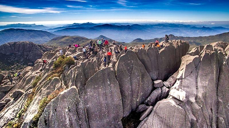
Pico das Agulhas Negras is the highest spot in the state of Rio de Janeiro and the fifth highest in the country, with about 2,790 meters of altitude) and the Maciço or Pico das Prateleiras (with over 1,5 miles of altitude). To get there, you will need to face a high dificulty level trail, as it contains exposed stretches that require the use of ropes.
If you manage to get through, the view from its top reveals a spectacular landscape, from which you will be able to see neighboring mountains such as Morro do Couto, Pico do Papagaio, and the Serra Fina Mountain in the background. - Pico das Prateleiras
The Pico das Prateleiras trail is considered easier then Pico das Agulhas Negras, consisting of a 6,1 miles trekking on a well-marked route. At the end, you will get a breathtaking panoramic view from its summit (it is possible to see the entire Paraíba Valley and other mountains of Itatiaia Park), a great place to take some amazing pictures to bring home as souvenirs.
How To Get To Parque Nacional do Itatiaia
The best way to get to Parque Nacional do Itatiaia is by landing at Rio de Janeiro’s International Airport (Aeroporto Internacional Tom Jobim – GIG) and then taking a bus (or renting a car) to Itatiaia, which should take you a little over 2 hours to complete.
You could also land at São Paulo’s International Airport (Governador André Franco Montoro Airport – GRU) and make the drive to the park, as both airports have pretty much similar distances to the Parque Nacional do Itatiaia.
If you are driving, while departing from either Rio de Janeiro or São Paulo, you must take the Presidente Dutra Highway (BR 116) to the city of Itatiaia. The trip takes approximately 2 h 30 min coming from Rio de Janeiro and 3 hours leaving São Paulo Paulo.
Best Time To Go To Parque Nacional do Itatiaia
The park can be visited every day of the year, but the best time to visit Parque Nacional do Itatiaia is during the winter (from June to August). Although the temperatures aren’t ideal for bathing at the local waterfalls, the dry weather during the winter makes less it likely for rainstorms and drizzle, which could make your trek much harder and dangerous.
What To Bring To Parque Nacional do Itatiaia
- a confortable pair of sneakers
- comfortable light clothing for trekking – some people wear jeans and only the top of the bikini, but leggings or sports shorts are much more comfortable for a long trail
- a long rope for climbing
- first-aid kit
- a flashlight
- a towel
- windbreaker jacket
- an extra pair of socks
- an extra change of clothes
- flip flops or sandals
- snacks
- garbage plastic bag for litter
10. Trekking do Descobrimento – Bahia (BA)
Course Lenght: 5 days
Difficulty Level: medium/high
Average Time to Complete: 4-5 hours (each day)
Guide Needed? yes
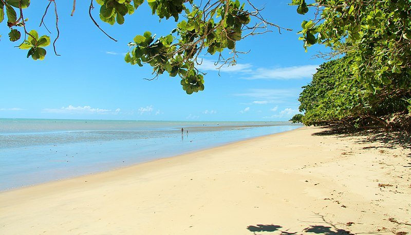
Bahia is a destination famous for its abundance of paradisiac beaches, and there is no better way to discover many of them at once than with one of the most exuberant crossings on the Brazilian coast. The Discovery Trek starts out in the south of Bahia (in Cumuruxatiba) and ends in one of the most beautiful places in the state and in the country, Trancoso (which we have previously talked about in this post).
You will pass through some of the most incredible landscapes, such as the large orange cliffs of Barra do Cahy, charming villages such as Caraíva, and, of course, beautiful beaches, some of them practically deserted, such as Corumbau, Jacumã, and the famous Praia do Espelho.
To explore all this, however, it is necessary to be in good physical condition, as although the trail does not present many technical hardships, it is considered a difficult level due to its length – almost 50 miles, which means you will be trekking for at least four or five days. Are you up to the challenge?
How To Get To Bahia (Cumuruxatiba)
The best way to get to Bahia is by landing at Porto Seguro’s International Airport (BPS) and then taking a travel bus or renting a car to complete the rest of the journey to Cumuruxatiba, which is where you will begin the trekking.
The average traveling time to one point from another is around 4 hours, and there are also minivans and other transportation options at the airport in case you don’t want to ride the bus or drive there yourself.
Best Time To Go To Bahia (Cumuruxatiba)
For the trekking fans, the best time to go to Bahia (Cumuruxatiba) is from May to October, as the temperature will be perfect for outdoor activities and there is almost no risk of rain, which makes walking the trails much easier. As the weather won’t be as humid as in the other periods, the trails also won’t be as slippery and it even makes the landscape much more beautiful as well.
What To Bring To Trekking do Descobrimento
- a good pair of hiking shoes (preferably waterproof)
- slippers or crocs
- 1 or 2 pieces of cotton clothing and a thick pair of socks for sleeping
- 5 pairs of socks (even with waterproof boots/sneakers, your socks will most likely get wet and wearing them wet can cause wounds, so it is better to take a few extra pair so you can change),
- 1 windbreaker coat
- 1 thermal suit to wear underneath your clothes
- 2 pair of confortable pants that allow you to move freely
- hat, a pair of gloves, a cap, a mask to protect your mouth and nose area
- 3 changes of clothing
- underwear
Other than that, it is also highly advisable for you to consider taking the following items:
- canteen
- water disinfectant
- bug spray
- the anti-allergic that you are used to taking (even with repellent some mosquitoes might still bite)
- vitamin C
- a sleeping bag
- camping tent (if you can’t take one, you can rent it with the guide)
- a thermal sleeping bag (for the ones who feel the most cold)
- head lamp
So, what did you think about our selections for the most astonishing trekkings in Brazil? There are many other beautiful trails you can journey throughout the country, but these are definitely some of the most picturesque ones that will surely grant you some unforgettable moments!
While you are here, I think we might interest you with these:
Traveling inside Brazil: a guide to transportation in the country – if you are planning on travelling throughout Brazil, flying to your destination may not always be the best choice! Check out this post and find out what are main ways of traveling in Brazil!
Do I Need Travel Insurance While Traveling to Brazil? – It is mandatory to hire the services of a travel insurance company in some countries, and also very recommendable if you are planning on engaging in any type of dangerous activities. Come find out how it works in Brazil!
Traveling to Brazil with a DUI record: all you need to know – if you are planning on driving in Brazil, but are worried about having a DUI record, take a look at this post! We got all the main info you need to drive safely inside the country!
Cover Photo: dawn at the Serra dos Orgãos National Park in Rio de Janeiro – Credit: Wiki Commons | Nilton Sergio Ramos Quoirin